The text that follows refers to the villages and hamlets of the
Municipality of Leuctro.
Very soon this Municipality will cease existing as it is about to be united with
the adjacent Municipality of
Avia into a larger municipality, the Municipality of
West Mani, following the state-wide Local and
Regional Elections of November 2010.
Athens, 11th November 2010
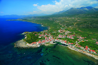
KARDAMYLI
 Kardamyli,
seat of the former Municipality
of Leuctro, is a village by
the sea, at a distance of 30 kilometers from Kalamata. It has 574 permanent
residents, according to the 1991 census, but the population increases at
summertime with tourists.
Kardamyli,
seat of the former Municipality
of Leuctro, is a village by
the sea, at a distance of 30 kilometers from Kalamata. It has 574 permanent
residents, according to the 1991 census, but the population increases at
summertime with tourists.
Kardamyli has a long history. It retains its Homeric name and is mentioned in
Homer’s Iliad (Book IX, v 149-153) as one of the seven “cities” which
Agamemnon planned to give Achilles as a dowry. What’s more, according to
tradition, it is here that the graves of the Dioscuri brothers, Castor and
Polydeuces, are located. The village features prominent families with
significant influence not only in the pre-revolutionary Hellenic lands but
afterwards, as well. These families played an important role in the preparation,
the outbreak, and the successful outcome of the Revolution. It was here that
Theodore Kolocotronis wintered before moving with his companions against
Kalamata on March 22 of 1821.
The historic sites of Kardamyli are concentrated at “Upper”, or “Old”,
Kardamyli. Ancient Kardamyli was not located on the sea. This is confirmed by
Pausanias who in his Laconica writes that Kardamyli lies “eight stadia” ([1]) from the sea. Here stands the
church of Agios Spyridon along with a number of tower-houses.
Other sights worth seeing are the stone-paved paths leading to the neighboring
hamlets of Agia Sophia and Petrovouni. The ascent to these
hamlets
will compensate the hikers with the beautiful view that they will enjoy.
Another nice hike, longer though, is to the monastery of Sotiras, in the Vyros
Ravine. The visitor of Kardamyli will notice a few tower-like constructions,
called by the locals “vardies”, which are located on hillocks. In the old times,
they were manned by villagers for the purpose of warning the inhabitants in the
case of approaching pirate ships. It is natural for someone to conclude that the
word “vardia” is a derivative of “guardia”, a word of Latin origin.
AGIA SOPHIA
Agia Sophia, or Gournitsa, is a small hamlet built on a hill near Kardamyli. It
is named after the church of the hamlet which is its only sight. It’s a small
church built of “porolithos” (see below for an explanation of porolithos), circa
1630. From here a narrow road leads down to the monastery of Sotiras, in the
Vyros Ravine.
PETROVOUNI
Like Agia Sophia, Petrovouni is also a hamlet built on a hill above Kardamyli.
From here the visitor has a marvelous view of Kardamyli, the plain with the
olive groves, the sea, and the Messenian coast beyond. Here there exist the
remains of the monastery of Panagia which belongs to the Holy Sepulcher, in
Jerusalem.
TSERIA
The village is built on the slope of a mountain and has a panoramic view of
Kardamyli and the Messenian Bay. It consists of six hamlets. Besides Tseria
itself, the other hamlets are Giatrehika, Zacharias (former Lipohova),
Katafygio (former Kopsolemehika), Pedino (former Kotsimarehika) and Leptini, or
Leftini.
At Zacharias there is the Koukeas tower-house, also known as the Zacharias Tower
named after Zacharias Barbitsiotis, an armatolos ([2]) who was murdered there in 1805. To reach
Tseria, one has to pass through the
village of Proselio.
The distance between the two villages is 5 kilometers. The road terminates here,
which means that in order to get back to the provincial road, the visitor has to
return to Proselio.
PROSELIO
The village of Proselio, or Liassinova, lies at a distance of 25 kilometers from
Kalamata and is built amphitheatrically on the slope of a mountain at an
altitude of 560 meters. Sights worth seeing here are the church of Agios
Georgios (1833) and the tower-house of the Patriarcheas family.
KALYVES
From Proselio, following the road to Kardamyli, the traveler passes by the
hamlet of Kalyves, built atop a small hillock. Not far from it, there is the
monastery of Sotiras, in the Vyros Ravine.
EXOCHORIO
Exochorio, Exochori or Xechori, is built at an altitude of 450 meters and is
located 8 km away from Kardamyli. Today, its residents are but a few dozen.
Yet, at the turn of the 20th century the village was the most populous in the
area. It suffices to say that it supported two elementary schools, one for boys
and one for girls, four parishes, and many olive-mills and water-driven
flour-mills.
Up to 1932, the village was named Androuvista, a name dating several centuries
back. Androuvista had been the seat of a diocese which was founded in 1630 and
lasted until 1833. At the time of the Frankish occupation of the Peloponnese,
Androuvista was raised to the status of Capetania, embracing the villages:
Chora, Exochori, Proastio, Saidona, Laccos, Petrovouni, Gournitsa, Liassinova,
Kalyves and Tseria.
With the establishment of the Greek
State and the ensuing abolition of the Capetanias, the villages of
Androuvista formed, in 1837, the
Municipality of Kardamyli.
Finally, following the administrative division of the country in 1937, the area
of Androuvista was incorporated into the Prefecture of Messenia. Today,
Exochorio is one of the Districts of the
Municipality of Leuctro.
The area flourished in the 18th and 19th centuries. Testimony of this is its
tower-houses and monasteries. Among these towers there should be mentioned the
one of the Fasseas family at Kolibetsehica, the other of the Procopeas family at
Chora, the Kitriniarehicos at Exochori and the Boukouvalehicos at Nicovo. Among
the monasteries the most well known were the ones of Panagia and of Samuel,
both situated at Vaidenitsa, a location near the village of Saidona which, as
mentioned, was one of the member-villages of the Capetania.
Exochori offers itself as a starting point for hiking escapes. One such escape
is to the Vyros Ravine below. Once there, one has three alternative paths to
take. The first is to go westward to the monastery of Sotiras and Kardamyli. The
second is to climb the path on the other side of the gorge that leads to the village of Tseria. The last is to follow the ravine eastward to
the Vassiliki
Forest and Mount
Taygetos.
Another hiking proposition is the ascent to the
Vassiliki
Forest from the other path, by way of
Vaidenitsa.
PROASTIO
Proastio, or Prastio, is located a couple of
kilometers from Kardamyli at an altitude of 250 meters. This old village
was built on a place that was out of the sight of the ships sailing along the
coast. It is said that it had been purposely built there for the fear of the
pirates who at those times raided the coastal villages.
Following the establishment of the
Greek
State, Proastio became the seat of the
Municipality of the same name. This Municipality consisted, besides Proastio,
of the villages of: Saidona, Laccos and Petrovouni. In 1840, it was absorbed
into the Municipality
of Kardamyli.
At the end of the village, on the way to Laccos and Exochori, there was (and
still exists) a quarry of sedimentary rock. This rock is known to the wider area
with the name “pori”.
At this site the inhabitants developed significant quarrying activity. With a
technique analogous to the one of marble quarrying, the villagers would cut the
rock into rectangular pieces, “porolithi” (sing. “porolithos”) and it was with
these pieces that they built houses and churches. Needless to say that cutting
the rock was a hard and time-consuming task, since it was performed manually.
Despite its small size, the village has several churches of which two are worth
mentioning: the Entrance of Virgin Mary,
with its 40-meter tall bell-tower, and Agios Nicolaos which is
situated in the middle of the village, by the main road. Below the village, at
the base of a hill, one can visit and enjoy the beaches of Kalamitsi and
Foneas.
LACCOS
At a small distance from the village, on the way to Exochori, one will reach the
hamlet of Laccos.
SAIDONA
Saidona is a village built amphitheatrically on the slope of
mount Sotiritsa
in the mountain range of Taygetos at an altitude of 600 meters. Its distance
from Kalamata is about 50 km. One may reach the village by way of Proastio and
Exochorio or by way of Neochorio and Pyrgos.
It is said that the first inhabitants settled here following the taking of
Constantinople by the Ottomans. This settlement is attested by the existence of
the two centuries old monasteries of Samuel and Vaidenitsa. The monastery of
Samuel was built circa 1480 by a monk called Samuel who, according to
tradition, had left Constantinople after the city’s fall. In about the same period, the
other monastery must have been built as well.
The village’s inhabitants have traditionally been industrious, with an inherent
tendency to struggle for freedom and the independence of the country. At a time
when none in Europe dared stand up and resist fascism and Nazism, it was Greece that resisted the
Axis. Among the first Greeks who resisted the conquerors were the Saidonites. In
May 1941, Saidonites would form the first armed band of resistance against the
Italian army contingent stationed in the area. In retaliation of this action the
Italians set fire to many houses of the village.
The village offers itself as a starting point for a number of alternative hiking
routes: to Exochorio, Kardamyli or to Exochorio, Tseria and, last but not least,
to the forest of Vassiliki
and Mount
Taygetos.
NEOCHORIO
Neochorio, or Niochori, is built at an altitude of 250 meters and is located 4
km east of the road leading from Kalamata to Gythion. The distance from Kalamata
to the road junction is about 45 km. It is a relatively new village which was
built in the 1700s from settlers who came from nearby villages, like Nomitsi,
Lagada, e.a. The village, together with the hamlets of Stoupa and Leuctro
constituted the Community of Neochori-Leuctro. Today, they constitute one of
the Districts of the Municipality
of Leuctro. In antiquity
the area was called Leuctra. Pausanias writes
that “Leuctra lies at twenty stadia from
Pefnos” an ancient city, which is currently where Platsa is located.
According to tradition, the first settlement was founded in the area around “the
Panagitsa of the Chioureas’ (family)”. The houses of the village are built
almost in contact to one another, leaving among them narrow lanes and tiny
squares. At the NE of the village, somewhat detached from it, stand “the
Mantzounehica” (an estate pertaining to the Mantzouneas clan).
The village has several churches to show. The village’s main church was
initially the “Panagitsa of the Chioureas’” which was built circa 1917. Later,
the church of Agios Nicolaos was built, adjacent to the village’s
cemetery. Today, the church
of The Annunciation, built
in 1978 and located at the east sector of the village, acts as the village’s
cathedral. Other churches worth mentioning are Agios Spyridon to the north and
that of Agios Nicolaos to the west, the latter built at a location where, in old
times, a stone-built apiary was operated by the Marambeas family. The village
has about 300 inhabitants who are mostly farmers engaged in the cultivation of
olive trees. There is also a small number of cattle-breeders and some who engage
in the tourism.
STOUPA
 Stoupa
is situated 6 km south of Kardamyli. The village started as a seaside hamlet of
Neochorio. As time passed by, however, the hamlet outgrew the mother village and
following the development of the tourism industry it became a well known summer
resort. Today, Stoupa has about 630 inhabitants.
Stoupa
is situated 6 km south of Kardamyli. The village started as a seaside hamlet of
Neochorio. As time passed by, however, the hamlet outgrew the mother village and
following the development of the tourism industry it became a well known summer
resort. Today, Stoupa has about 630 inhabitants.
The village is relatively new but its very good beaches, especially the one of
Kalogria, have made it well known and an excellent summer destination. Here,
author Nikos Kazantzakis and his business partner Zorbas set out to operate a
mine. Though the venture failed it was here that Kazantzakis conceived his
well-known work “Alexis Zorbas”.
Near the village, there rises a hillock with remnants of what used to be the
Frankish Castle of Beaufort built by Villearduine circa 1250 and of which
mention is made in the 14th century Chronicle of the Morea.
Within walking distance from the village is the hamlet of Leuctro which has 170
inhabitants, several of them of foreign citizenship.
PYRGOS
Pyrgos is situated at a distance of 50 km from Kalamata and 5 from Stoupa. In
the beginning of the 20th century, its inhabitants numbered just a few hundred
engaged in the cultivation of the land and the breeding of cattle. Because the
land could not feed all inhabitants, many of them either migrated to other
cities of Greece or emigrated to the United States, initially, and later to
Australia and Germany. Today, its population is no more than a few dozen people
who are mainly employed in the cultivation of olive trees.
The village’s patron saint is Agios Georgios and his church is located in a
place from which one can enjoy the view of the sea and the setting sun.
KARYOVOUNI
Karyovouni, formerly called Arachova, is a mountain village located 10 km from
Stoupa. Its houses are built on either side of a small ravine, the sides being
connected by three small bridges.
Dryopi, former Piala, is a hamlet near Karyovouni which, in contrast to the
latter, has an open view of the villages of Agios Nicolaos and Stoupa and of the
plain with olive groves.
AGIOS NICOLAOS
Agios Nicolaos, or Selinitsa
as it was formerly called, is a village by the sea and its first inhabitants
used to engage themselves almost exclusively with fishing. After the
construction of a small port, wood vessels, called “benzinas”, started regular
communication service with the town of Kalamata given that at the time there
was no road system. Through its port, Selinitsa served the population of the
nearby villages and became the hub of local commerce.
The old village, with its
characteristic stone, two-story houses, was initially built around its small
port. These houses are known by the names of their original owners: e.g. the
house of Kelepouris, the house of Strateas, the house of doctor Cybelos, or the
one of doctor Kallergis, at Gnospi. ([3])
As time passed, the village
started to gradually draw the attention of tourists and summer vacationers, as
did Stoupa and Kardamyli, despite the fact that, owing to the rocky formation of
its coastline it has no beaches, with the exception of the beach called Pantazi.
AGIOS DIMITRIOS
The hamlet is located very near to the
village
of Agios Nicolaos. The
hamlet is known for the tower-house of Captain Christodoulos Christeas.
Following the road to the next hamlet, Trachela, at 2 km, one reaches a cave by
the sea, known to the locals by the name “Katafygio” which according to experts
is very interesting.
TRACHELA
 Trachela
is a hamlet of a few houses by the sea. It is located at about 9.5 km from
nearby Agios Nicolaos with which it is connected by a road built as late as
1970. Until then, transportation was carried out exclusively by the sea. The
hamlet acted as a seaport of the larger
village
of Lagada but it equally
served all nearby villages.
Trachela
is a hamlet of a few houses by the sea. It is located at about 9.5 km from
nearby Agios Nicolaos with which it is connected by a road built as late as
1970. Until then, transportation was carried out exclusively by the sea. The
hamlet acted as a seaport of the larger
village
of Lagada but it equally
served all nearby villages.
RIGLIA
Riglia is a small village located on the left of the road leading from Kalamata
to Gythion, at the level of Agios Nicolaos. The village and the nearby hamlet of
Eleochorio, or Isina, constitute one of the Districts of the
Municipality of Leuctro.
PLATSA
Platsa is a village built at an altitude of 370 meters. It is said that here was
the location of ancient Pefnos. In the area there are several small churches the
origin of which dates back to the Byzantine era. Among them, mention should be
made of Agios Nicolaos, standing at the site known as Cabinari. Near Platsa
there are also the hamlets of Pigi and Cotroni.
PIGI
Pigi, formerly called Losna, is located at about 54 km from Kalamata and is
built at an altitude of 250 meters. In the beginning of the 20th century, its
inhabitants numbered about 300. The
patron saint of the village is the Assumption of the Virgin Mary.
MILEA
As one follows the road towards Milea, at 4 km from Platsa, one reaches the
hamlet of Cybelia, former Garbelia. A little further on, there is Milea or
Milia, home village of Nikitas Nifakos, poet of Mani. Milea is located on
the boundary line delimiting the Prefectures of Messenia and
Laconia. The village actually
consists of 5 hamlets one of which is Xanthianika.
NOMITSI
Nomitsi is located between Platsa and Thalames (Koutifari). In and around the
village, as it happens in most of the villages in the wider area, there are many
little churches of Byzantine architecture, evidence of the devoutness of the
local population in those times. The village’s main church is the one of Agios
Georgios, the bell-tower of which dates back to 1730.
THALAMES
Thalames, or Koutifari, is a mountain village located 20 km from Kardamyli.
Close to the village there are the hamlets Platanos and Somatiana. The area had
been granted by the Byzantines as estate to a nobleman named Ioannis Koutifaris
and that’s how the village took its name.
In the village there operated a workshop of iconography which produced many
Maniotes iconographers who decorated with their paintings many churches in Mani
and elsewhere.
LAGADA
The village is built amphitheatrically on the slope of a hill, between two small
ravines, and to this it owes its name. It is a very old village with origins in
antiquity. Several tower-houses have survived the time, among which are the
towers of Kapitsinos and Economeas as well as the house of Kiskiras (1859).
Among the churches, the one of Christ’s Transfiguration should be mentioned
which, it is said, was built about a thousand years ago.
KASTANIA
Kastania is a mountain village built at an altitude of 560 meters. Its distance
from Saidona and Kardamyli is 3 and 15 km, respectively. The village is hidden
in a ravine and cannot be detected unless one reaches close proximity to it. One
of the sites of the village is the tower-house of Capetan Dourakis in which
Theodore Kolocotronis took refuge during the time of the great persecution of
the Kleftes a few years before the declaration of the Revolution.
AGIOS NIKON
Until 1940, the name of the village was Poliana. It is the last village of
Messenian Mani, on the road from Kalamata to Gythion. Its name was changed to
Agios Nikon in honour of Agios Nikon “the Repent” (Oh Metanohite) who, centuries ago,
used to go about preaching the Gospel among the Slav tribe of Melligi who, in
the second half of the 10th century AD, had descended and set roots on the
western, mountainous, side of Taygetos known since then by the name of Zygos.
At the location known as the Big Rock (Megali Petra) there is the church of the
Archangels Michael and Gabriel which was originally a monastery. The village’s
main church is the church
of Sotiras.
[1]
A stadion (pl. stadia) is an ancient Greek unit of length used for itinerary distances.
According to Herodotus, one stadion is equal to 600 Greek feet. Since in ancient
Attica one foot would equal 308 mm, a stadion measures 185 meters
(607 feet).
[2]
Armatoloi (pron. ar-ma-to-LEE) were Greek Christian irregular soldiers commissioned by the
Ottomans to enforce the Sultan’s authority within an administrative district
called an Armatoliki. Often, they were hired by the governing Pasha to contain
brigand groups in the region. Over time, especially during the Greek War of
Independence, many armatoloi reversed allegiance and turned against their
employers.
[3]
Reference to this house of historic interest is made in
Oh Gerontas (The old man), by Yannis
Goudelis, editions Difros, Athens, 1983, (1st edition 1964)